Login

Zapomniałeś swój login?

Cookies have to be accepted!
Your browser's cookie functionality is disabled. Please enable this functionality.

Not a member yet?

Register now
Login

Available for registred users only

Log in to use this feature.

Zapomniałeś swój login?

Cookies have to be accepted!
Your browser's cookie functionality is disabled. Please enable this functionality.

Not a member yet?

Register now
Filter
Kategorie
Advanced filters
  • Długość (km)
  • Wysokość
Zapisz filtr Reset filter

TrackRank

QRCode

Technical data

Długość205,2 km Wysokość3647 m Way down3643 m Czas trwania08:43 h:m Data26.06.2006
Oceny Author Krajobraz Czynnik zadowolenia Kondycja Technika

Statystyka

2165 Widoki 1 Ocena 297 Downloads / Pliki do pobrania 4.00 Przeciętnie
Rate
  • Karta trasy
  • Dojazd
  • Downloads / Pliki do pobrania

Galeria trasy

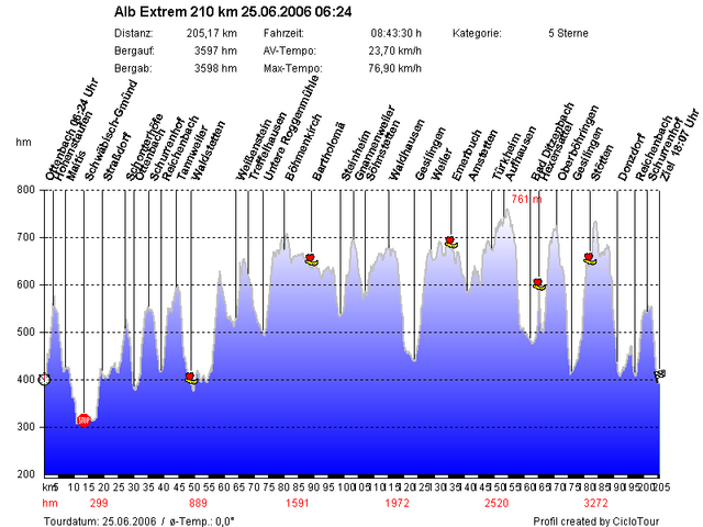
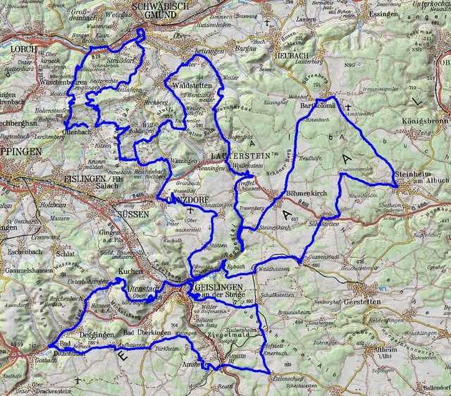
Mapa trasy i profil wysokości

  • Open Street Map
  • Google
Minimum height 303 m Maximum height 761 m Widok szczegółowy

More about the tour author

gemsweb
Member since 2006

Send private message

Komentarze

upndown on 30.06.2006

Strecke und Temperatur

Hi, die Strecke war ja mal wieder etwas geändert. Der Anstieg von Reichenbach zum Schurrenhof und von Ottenbach zum Schurrenhof am Morgen war ja zum ersten mal enthalten. Ich empfand es als eine Bereicherung ohne viel Verkehr.

Die Temperatur war ja mal wieder am oberen Limit, so daß ich am Hexensattel die Kopfdusche aus dem Wasserfaß genossen habe.

GPS tracks

Trackpoints
  • GPX / Garmin Map Source (gpx) download
  • TCX / Garmin Training Center® (tcx) download
  • CRS / Garmin Training Center® (crs) download
  • Google Earth (kml) download
  • G7ToWin (g7t) download
  • TTQV (trk) download
  • Overlay (ovl) download
  • Fugawi (txt) download
  • Kompass (DAV) Track (tk) download
  • Karta trasy (pdf) download
  • Original file of the author (gpx) download

More about the tour author

gemsweb
Member since 2006

Send private message
Share track
Add to my favorites
Remove from my favorites
Edit tags
My score
Rate
Trasa: Alb Extrem 210 km 25.06.2006
Rodzaj: Rower szosowy
Długość: 205,2 km
Evaluated on:
Czas trwania:
Day(s)
Hour(s)
Minute(s)
Ocena: Krajobraz Czynnik zadowolenia Kondycja Technika