Login

Zapomniałeś swój login?

Cookies have to be accepted!
Your browser's cookie functionality is disabled. Please enable this functionality.

Not a member yet?

Register now
Login

Available for registred users only

Log in to use this feature.

Zapomniałeś swój login?

Cookies have to be accepted!
Your browser's cookie functionality is disabled. Please enable this functionality.

Not a member yet?

Register now
Filter
Kategorie
Advanced filters
  • Długość (km)
  • Wysokość
Zapisz filtr Reset filter

TrackRank

QRCode

Technical data

Długość79,3 km Wysokość919 m Way down976 m Czas trwania03:00 h:m Data28.06.2006
Oceny Author Krajobraz Czynnik zadowolenia Kondycja Technika

Statystyka

810 Widoki Oceny 158 Downloads / Pliki do pobrania Przeciętnie
Rate
  • Karta trasy
  • Dojazd
  • Downloads / Pliki do pobrania
Sehr schöne Runde zunächst Richtung Falkenstein, dann in in einem kleinen Dorf (Stadl) Richtung Norden auf kleinen Straßen nach Nittenau und über Kürn mit weiteren teils heftigen kurzen Anstiegen zurück nach Regensburg.

Galeria trasy

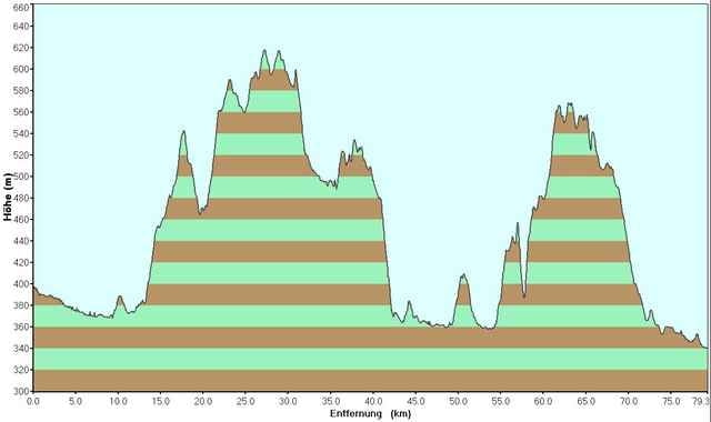
Mapa trasy i profil wysokości

  • Open Street Map
  • Google
Minimum height 340 m Maximum height 617 m Widok szczegółowy

More about the tour author

tobi_74

Komentarze

Der Startpunkt befindet sich im Nordosten von Regensburg, dem Gewerbepark.

GPS tracks

Trackpoints
  • GPX / Garmin Map Source (gpx) download
  • TCX / Garmin Training Center® (tcx) download
  • CRS / Garmin Training Center® (crs) download
  • Google Earth (kml) download
  • G7ToWin (g7t) download
  • TTQV (trk) download
  • Overlay (ovl) download
  • Fugawi (txt) download
  • Kompass (DAV) Track (tk) download
  • Karta trasy (pdf) download
  • Original file of the author (gpx) download

More about the tour author

tobi_74

Share track
Add to my favorites
Remove from my favorites
Edit tags
My score
Rate
Trasa: Regensburg - Stadl, Nittenau
Rodzaj: Rower szosowy
Długość: 79,3 km
Evaluated on:
Czas trwania:
Day(s)
Hour(s)
Minute(s)
Ocena: Krajobraz Czynnik zadowolenia Kondycja Technika