Login

Zapomniałeś swój login?

Cookies have to be accepted!
Your browser's cookie functionality is disabled. Please enable this functionality.

Not a member yet?

Register now
Login

Available for registred users only

Log in to use this feature.

Zapomniałeś swój login?

Cookies have to be accepted!
Your browser's cookie functionality is disabled. Please enable this functionality.

Not a member yet?

Register now
Filter
Kategorie
Advanced filters
  • Długość (km)
  • Wysokość
Zapisz filtr Reset filter

TrackRank

QRCode

Technical data

Długość103,9 km Wysokość961 m Way down958 m Czas trwania03:45 h:m Data09.08.2009
Oceny Author Krajobraz Czynnik zadowolenia Kondycja Technika

Statystyka

289 Widoki Oceny 45 Downloads / Pliki do pobrania Przeciętnie
Rate
  • Karta trasy
  • Dojazd
  • Downloads / Pliki do pobrania

Schöne RTF vom RSC Schwalbe Aßlar.

Sehr gute Ausschilderung und Verpflegung. Vielen Dank den Organisatoren und Helfern.

Die zusätzlichenBilder zeigen die Mannschaft der PVA TePla Sports e.V., die den Wanderpokal für das zahlenmäßig am stärksten vertretene Team außerhalb des BDR gewonnen hat.

Further information at

http://www.pvatepla-sports.com

Galeria trasy

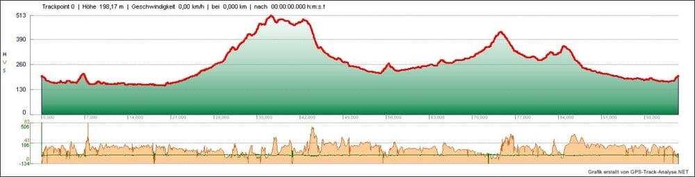
Mapa trasy i profil wysokości

  • Open Street Map
  • Google
Minimum height 151 m Maximum height 513 m Widok szczegółowy

More about the tour author

tombbmot
Member since 2009

Send private message

Komentarze

GPS tracks

Trackpoints
  • GPX / Garmin Map Source (gpx) download
  • TCX / Garmin Training Center® (tcx) download
  • CRS / Garmin Training Center® (crs) download
  • Google Earth (kml) download
  • G7ToWin (g7t) download
  • TTQV (trk) download
  • Overlay (ovl) download
  • Fugawi (txt) download
  • Kompass (DAV) Track (tk) download
  • Karta trasy (pdf) download
  • Original file of the author (gpx) download

More about the tour author

tombbmot
Member since 2009

Send private message
Share track
Add to my favorites
Remove from my favorites
Edit tags
My score
Rate
Trasa: RTF "Rund um Aßlar" 104km
Rodzaj: Rower szosowy
Długość: 103,9 km
Evaluated on:
Czas trwania:
Day(s)
Hour(s)
Minute(s)
Ocena: Krajobraz Czynnik zadowolenia Kondycja Technika