Login

Zapomniałeś swój login?

Cookies have to be accepted!
Your browser's cookie functionality is disabled. Please enable this functionality.

Not a member yet?

Register now
Login

Available for registred users only

Log in to use this feature.

Zapomniałeś swój login?

Cookies have to be accepted!
Your browser's cookie functionality is disabled. Please enable this functionality.

Not a member yet?

Register now
Filter
Kategorie
Advanced filters
  • Długość (km)
  • Wysokość
Zapisz filtr Reset filter

TrackRank

QRCode

Technical data

Długość12,7 km Wysokość1316 m Way down1302 m Czas trwania06:00 h:m Data22.08.2009
Oceny Author Krajobraz Czynnik zadowolenia Kondycja Technika

Statystyka

751 Widoki Oceny 90 Downloads / Pliki do pobrania Przeciętnie
Rate
  • Karta trasy
  • Dojazd
  • Downloads / Pliki do pobrania

Ein gut machbarer Dreitausender, der meiner Meinung nach keine übermäßig hohen Anforderungen stellt. Trittsicherheit und Grundkondition sollten allerdings vorhanden sein.

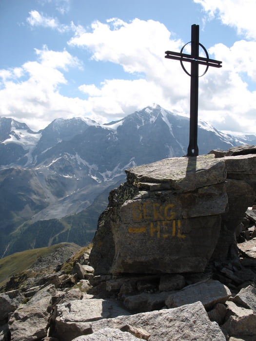
Oben angekommen ergibt sich eine einzigartige Aussicht, sowie ein herrlicher Blick auf den Ortler (de.wikipedia.org/wiki/Ortler)!

Zwischenziel / Rastmöglichkeit: Kälberalm

Mein Hinweg:  Wegnummer 25

Mein Rückweg: Wegnummer 19


Galeria trasy

Mapa trasy i profil wysokości

  • Open Street Map
  • Google
Minimum height 1862 m Maximum height 3132 m Widok szczegółowy

More about the tour author

marei
Member since 2008

Send private message

Komentarze

Die Tour beginnt in Sulden.

Parkmöglichkeiten sind ausreichend vorhanden.

GPS tracks

Trackpoints
  • GPX / Garmin Map Source (gpx) download
  • TCX / Garmin Training Center® (tcx) download
  • CRS / Garmin Training Center® (crs) download
  • Google Earth (kml) download
  • G7ToWin (g7t) download
  • TTQV (trk) download
  • Overlay (ovl) download
  • Fugawi (txt) download
  • Kompass (DAV) Track (tk) download
  • Karta trasy (pdf) download
  • Original file of the author (gpx) download

More about the tour author

marei
Member since 2008

Send private message
Share track
Add to my favorites
Remove from my favorites
Edit tags
My score
Rate
Trasa: Bergtour zum hinteren Schöneck auf 3128 m
Rodzaj: Trasy górskie
Długość: 12,7 km
Evaluated on:
Czas trwania:
Day(s)
Hour(s)
Minute(s)
Ocena: Krajobraz Czynnik zadowolenia Kondycja Technika