Login

Zapomniałeś swój login?

Cookies have to be accepted!
Your browser's cookie functionality is disabled. Please enable this functionality.

Not a member yet?

Register now
Login

Available for registred users only

Log in to use this feature.

Zapomniałeś swój login?

Cookies have to be accepted!
Your browser's cookie functionality is disabled. Please enable this functionality.

Not a member yet?

Register now
Filter
Kategorie
Advanced filters
  • Długość (km)
  • Wysokość
Zapisz filtr Reset filter

TrackRank

QRCode

Technical data

Długość7,2 km Wysokość182 m Way down160 m Czas trwania03:00 h:m Data03.09.2009
Oceny Author Krajobraz Czynnik zadowolenia Kondycja Technika

Statystyka

565 Widoki Oceny 33 Downloads / Pliki do pobrania Przeciętnie
Rate
  • Karta trasy
  • Dojazd
  • Downloads / Pliki do pobrania

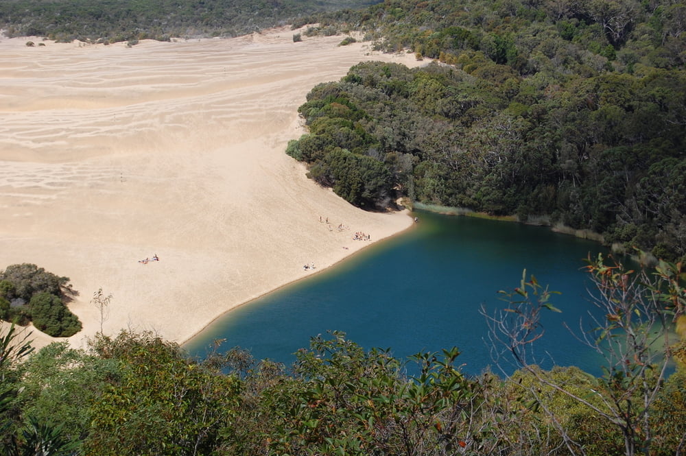
Schöne Wanderung zum Lake Wabby und weiter zu einem kleinen Aussichtspunkt.

Am Lake Wabby besteht die Möglichkeit zu baden.

Wanderung ist ausgeschildert und problemlos auch in Flip Flops zu bewältigen.


Galeria trasy

Mapa trasy i profil wysokości

  • Open Street Map
  • Google
Minimum height 5 m Maximum height 118 m Widok szczegółowy

More about the tour author

schuh
Member since 2008

Send private message

Komentarze

Nördlich von Eurong auf Fraser Island

GPS tracks

Trackpoints
  • GPX / Garmin Map Source (gpx) download
  • TCX / Garmin Training Center® (tcx) download
  • CRS / Garmin Training Center® (crs) download
  • Google Earth (kml) download
  • G7ToWin (g7t) download
  • TTQV (trk) download
  • Overlay (ovl) download
  • Fugawi (txt) download
  • Kompass (DAV) Track (tk) download
  • Karta trasy (pdf) download
  • Original file of the author (gpx) download

More about the tour author

schuh
Member since 2008

Send private message
Share track
Add to my favorites
Remove from my favorites
Edit tags
My score
Rate
Trasa: Wanderung zum Lake Wabby
Rodzaj: Wędrówki
Długość: 7,2 km
Evaluated on:
Czas trwania:
Day(s)
Hour(s)
Minute(s)
Ocena: Krajobraz Czynnik zadowolenia Kondycja Technika