Login

Zapomniałeś swój login?

Cookies have to be accepted!
Your browser's cookie functionality is disabled. Please enable this functionality.

Not a member yet?

Register now
Login

Available for registred users only

Log in to use this feature.

Zapomniałeś swój login?

Cookies have to be accepted!
Your browser's cookie functionality is disabled. Please enable this functionality.

Not a member yet?

Register now
Filter
Kategorie
Advanced filters
  • Długość (km)
  • Wysokość
Zapisz filtr Reset filter

TrackRank

QRCode

Technical data

Długość17,0 km Wysokość369 m Way down362 m Czas trwania01:25 h:m Data16.04.2004
Oceny Author Krajobraz Czynnik zadowolenia Kondycja Technika

Statystyka

1909 Widoki 1 Ocena 257 Downloads / Pliki do pobrania 3.00 Przeciętnie
Rate
  • Karta trasy
  • Dojazd
  • Downloads / Pliki do pobrania
Kurze Trainingsrunde, schnell und knackig.

Mapa trasy i profil wysokości

  • Open Street Map
  • Google
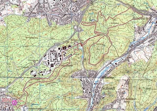
Minimum height 254 m Maximum height 352 m Widok szczegółowy

More about the tour author

abusch

Komentarze

Pascal W. on 23.02.2008

Kommentar zur Tour

War eine sehr Schöne Tour die mir gut gefallen hat.
Bin sie abends nach dem Feierabend gefahren und bin die letzten 30 minuten im dücklen gefahren (habe natürlich eine gute Licht ausrustung). Ich werde sie wieder fahren aber diesmal morgens und mit einem Freund.
Mit mehr Single Trails wäre die Tour noch besser.
Saarbrücken Scheidter Strasse bis zum Ende (Rotenbühel), am Kreisel parken

GPS tracks

Trackpoints
  • GPX / Garmin Map Source (gpx) download
  • TCX / Garmin Training Center® (tcx) download
  • CRS / Garmin Training Center® (crs) download
  • Google Earth (kml) download
  • G7ToWin (g7t) download
  • TTQV (trk) download
  • Overlay (ovl) download
  • Fugawi (txt) download
  • Kompass (DAV) Track (tk) download
  • Karta trasy (pdf) download
  • Original file of the author (g7t) download

More about the tour author

abusch

Share track
Add to my favorites
Remove from my favorites
Edit tags
My score
Rate
Trasa: Bartenberg
Rodzaj: Rower górski (MTB)
Długość: 17,0 km
Evaluated on:
Czas trwania:
Day(s)
Hour(s)
Minute(s)
Ocena: Krajobraz Czynnik zadowolenia Kondycja Technika