Login

Zapomniałeś swój login?

Cookies have to be accepted!
Your browser's cookie functionality is disabled. Please enable this functionality.

Not a member yet?

Register now
Login

Available for registred users only

Log in to use this feature.

Zapomniałeś swój login?

Cookies have to be accepted!
Your browser's cookie functionality is disabled. Please enable this functionality.

Not a member yet?

Register now
Filter
Kategorie
Advanced filters
  • Długość (km)
  • Wysokość
Zapisz filtr Reset filter

TrackRank

QRCode

Technical data

Długość37,1 km Wysokość1044 m Way down900 m Czas trwania04:00 h:m Data30.10.2009
Oceny Author Krajobraz Czynnik zadowolenia Kondycja Technika

Statystyka

264 Widoki Oceny 44 Downloads / Pliki do pobrania Przeciętnie
Rate
  • Karta trasy
  • Dojazd
  • Downloads / Pliki do pobrania

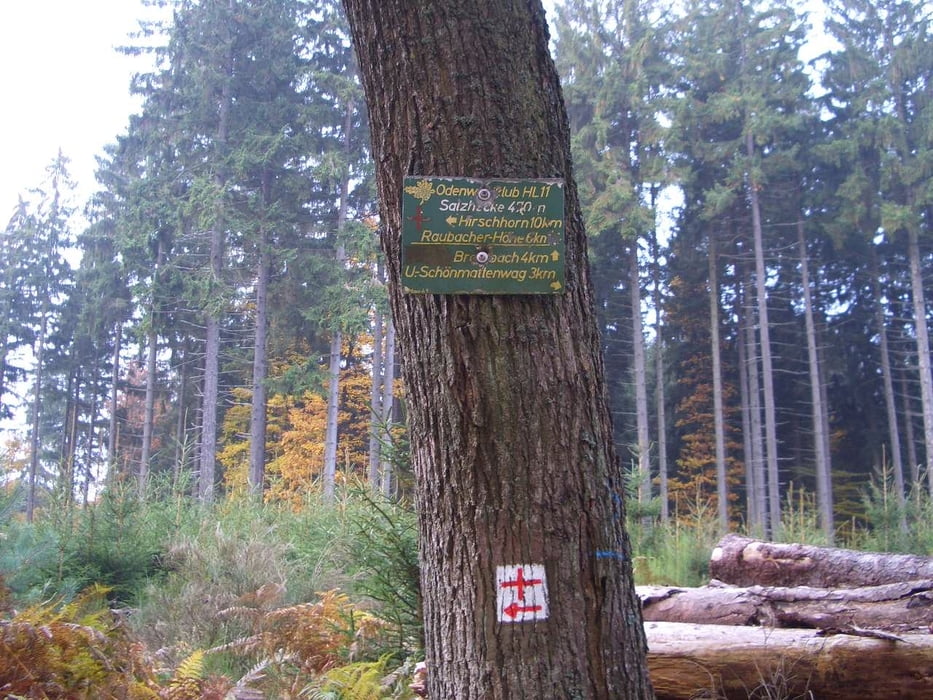
Hier eine Tour von Siedelsbrunn durch's Ulfenbachtal hinauf zum "Roten Kreuzweg".

Diesen folgen bis nach Hirschhorn. Schöner Trail hinunter nach Hirschhorn. Dann auf der linken Ulfenbachseite bis oberhalb von Langental. Anschließend hoch Richtung Wolfsgrube auf den "Weg mit dem Roten Quadrat" und zurück über Schönbrunn nach Siedelsbrunn.


Viel Spaß bei dieser Tour!


Hardberg

Galeria trasy

Mapa trasy i profil wysokości

  • Open Street Map
  • Google
Minimum height 131 m Maximum height 534 m Widok szczegółowy

More about the tour author

Hardberg
Member since 2008

Send private message

Komentarze

GPS tracks

Trackpoints
  • GPX / Garmin Map Source (gpx) download
  • TCX / Garmin Training Center® (tcx) download
  • CRS / Garmin Training Center® (crs) download
  • Google Earth (kml) download
  • G7ToWin (g7t) download
  • TTQV (trk) download
  • Overlay (ovl) download
  • Fugawi (txt) download
  • Kompass (DAV) Track (tk) download
  • Karta trasy (pdf) download
  • Original file of the author (gpx) download

More about the tour author

Hardberg
Member since 2008

Send private message
Share track
Add to my favorites
Remove from my favorites
Edit tags
My score
Rate
Trasa: Rund ums südliche Ulfenbachtal
Rodzaj: Rower górski (MTB)
Długość: 37,1 km
Evaluated on:
Czas trwania:
Day(s)
Hour(s)
Minute(s)
Ocena: Krajobraz Czynnik zadowolenia Kondycja Technika