Login

Zapomniałeś swój login?

Cookies have to be accepted!
Your browser's cookie functionality is disabled. Please enable this functionality.

Not a member yet?

Register now
Login

Available for registred users only

Log in to use this feature.

Zapomniałeś swój login?

Cookies have to be accepted!
Your browser's cookie functionality is disabled. Please enable this functionality.

Not a member yet?

Register now
Filter
Kategorie
Advanced filters
  • Długość (km)
  • Wysokość
Zapisz filtr Reset filter

TrackRank

QRCode

Technical data

Długość111,7 km Wysokość421 m Way down422 m Czas trwania04:00 h:m Data08.04.2010
Oceny Author User Krajobraz Czynnik zadowolenia Kondycja Technika

Statystyka

984 Widoki 2 Oceny 219 Downloads / Pliki do pobrania 3.00 Przeciętnie
Rate
  • Karta trasy
  • Dojazd
  • Downloads / Pliki do pobrania

 Ich gestehe dass mir diese Gegend gut gefällt und ich bin überzeugt dass es eine ideales Terrain für das Training ist. Es gibt kurze Anstiege wo die Muskeln ordentlich gefordert werden dann kommt die Abfahrt zum regenerieren und entspannen und dann gibt es genügend Flachstücke wo man die Ausdauer trainiert.

Es ist praktisch nutzlos die Strecke zu erklären denn es gibt so viele Varianten und Nebenstrassen dass man schier den Überblick verliert.

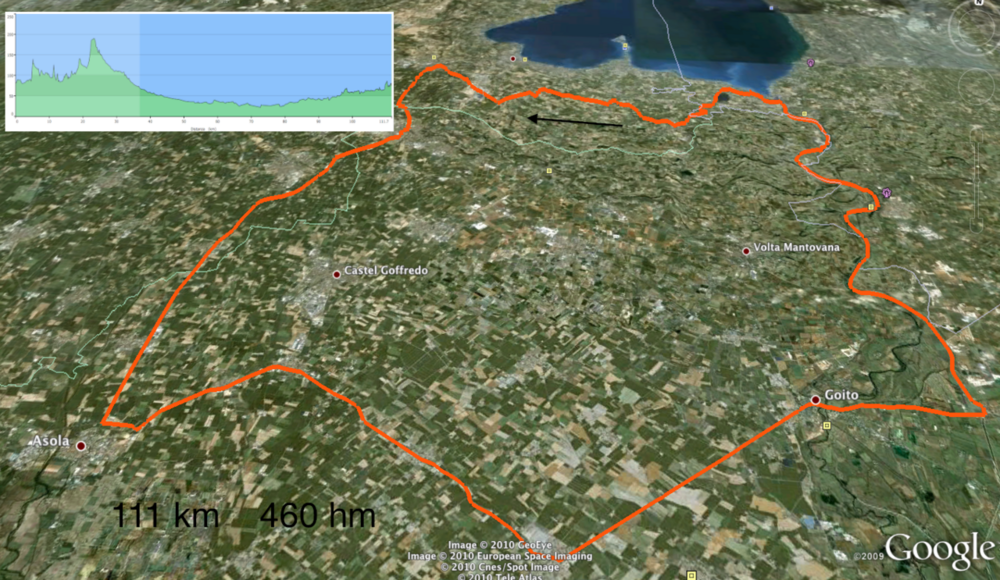
Mapa trasy i profil wysokości

  • Open Street Map
  • Google
Minimum height 21 m Maximum height 190 m Widok szczegółowy

More about the tour author

EmilG
Member since 2008

Send private message

Komentarze

GPS tracks

Trackpoints
  • GPX / Garmin Map Source (gpx) download
  • TCX / Garmin Training Center® (tcx) download
  • CRS / Garmin Training Center® (crs) download
  • Google Earth (kml) download
  • G7ToWin (g7t) download
  • TTQV (trk) download
  • Overlay (ovl) download
  • Fugawi (txt) download
  • Kompass (DAV) Track (tk) download
  • Karta trasy (pdf) download
  • Original file of the author (gpx) download

More about the tour author

EmilG
Member since 2008

Send private message
Share track
Add to my favorites
Remove from my favorites
Edit tags
My score
Rate
Trasa: Peschiera del Garda 1
Rodzaj: Rower szosowy
Długość: 111,7 km
Evaluated on:
Czas trwania:
Day(s)
Hour(s)
Minute(s)
Ocena: Krajobraz Czynnik zadowolenia Kondycja Technika