Login

Zapomniałeś swój login?

Cookies have to be accepted!
Your browser's cookie functionality is disabled. Please enable this functionality.

Not a member yet?

Register now
Login

Available for registred users only

Log in to use this feature.

Zapomniałeś swój login?

Cookies have to be accepted!
Your browser's cookie functionality is disabled. Please enable this functionality.

Not a member yet?

Register now
Filter
Kategorie
Advanced filters
  • Długość (km)
  • Wysokość
Zapisz filtr Reset filter

TrackRank

QRCode

Technical data

Długość23,2 km Wysokość663 m Way down626 m Czas trwania05:00 h:m Data07.05.2010
Oceny Author Krajobraz Czynnik zadowolenia Kondycja Technika

Statystyka

3833 Widoki Oceny 230 Downloads / Pliki do pobrania Przeciętnie
Rate
  • Karta trasy
  • Dojazd
  • Downloads / Pliki do pobrania

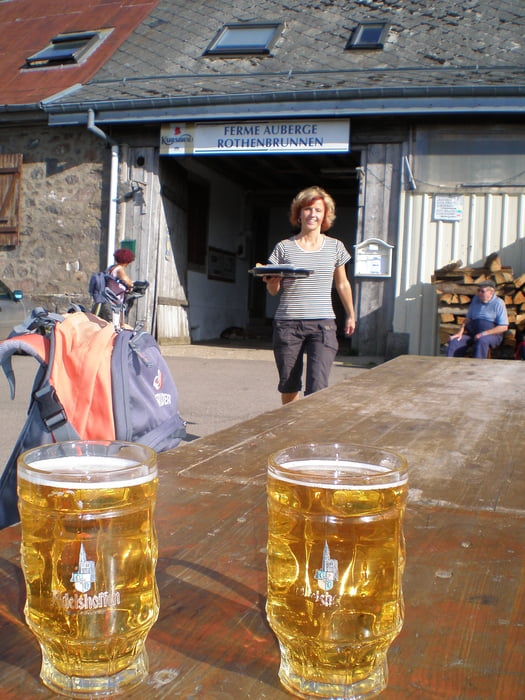
Start dieser Wanderung ist in Landersen (800 m). In süd-östlicher Richtung geht es zum Col du Oberlauchen. Weiter über den Klintzkopf (1320 m)  vorbei an einem Bunker aus dem ersten Weltkrieg zum Col du Hilsenfirst  (1120 m) zur urigen Ferme Auberge Rothenbrunnen. Von hier aus ist es noch ein Katzensprung auf den Petit Ballon. Mir war an dem heißen Tag aber ein kühles Bierchen lieber....

Viel Spaß!

Jörn Koberne

Galeria trasy

Mapa trasy i profil wysokości

  • Open Street Map
  • Google
Minimum height 813 m Maximum height 1332 m Widok szczegółowy

More about the tour author

Kobi
Member since 2008

Send private message

Komentarze

Colmar - Munster - Sondernach - D27 links abbiegen hinauf nach Landersen

GPS tracks

Trackpoints
  • GPX / Garmin Map Source (gpx) download
  • TCX / Garmin Training Center® (tcx) download
  • CRS / Garmin Training Center® (crs) download
  • Google Earth (kml) download
  • G7ToWin (g7t) download
  • TTQV (trk) download
  • Overlay (ovl) download
  • Fugawi (txt) download
  • Kompass (DAV) Track (tk) download
  • Karta trasy (pdf) download
  • Original file of the author (gpx) download

More about the tour author

Kobi
Member since 2008

Send private message
Share track
Add to my favorites
Remove from my favorites
Edit tags
My score
Rate
Trasa: Wanderung am petit ballon
Rodzaj: Wędrówki
Długość: 23,2 km
Evaluated on:
Czas trwania:
Day(s)
Hour(s)
Minute(s)
Ocena: Krajobraz Czynnik zadowolenia Kondycja Technika