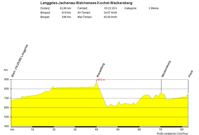
Start ist in Lenggries. Zuerst geht es durch die Jachenau zum Walchensee, welcher anschliessend westseitig umkreist wird. Nach kurzem Anstieg zum Kesselberg erfolgt die Abfahrt nach Kochel. Dann geht es über Benediktbeuern, Bichl, Bad Heilbrunn und Wackersberg zurück zum Ausgangspunkt.
Schöne Rennradstrecke, allerdings ist der Abschnitt Kochel-Bad Heilbrunn teilweise stark befahren und der Radweg zwischen Bad Heilbrunn und Stallau ist ziemlich holprig.
Schöne Rennradstrecke, allerdings ist der Abschnitt Kochel-Bad Heilbrunn teilweise stark befahren und der Radweg zwischen Bad Heilbrunn und Stallau ist ziemlich holprig.
Mapa trasy i profil wysokości
Minimum height 606 m
Maximum height 870 m
Komentarze
GPS tracks
Trackpoints-
GPX / Garmin Map Source (gpx) download
-
TCX / Garmin Training Center® (tcx) download
-
CRS / Garmin Training Center® (crs) download
-
Google Earth (kml) download
-
G7ToWin (g7t) download
-
TTQV (trk) download
-
Overlay (ovl) download
-
Fugawi (txt) download
-
Kompass (DAV) Track (tk) download
-
Karta trasy (pdf) download
-
Original file of the author (gpx) download
Add to my favorites
Remove from my favorites
Edit tags
Open track
My score
Rate


Wunderbare Einrolltour
Bin diese Tour jetzt am Wochenende bei herrlich milden Temparaturen gefahren. Sie ist nur zu empfehlen
Viele Grüße
Schjöne Abendtour