Login

Zapomniałeś swój login?

Cookies have to be accepted!
Your browser's cookie functionality is disabled. Please enable this functionality.

Not a member yet?

Register now
Login

Available for registred users only

Log in to use this feature.

Zapomniałeś swój login?

Cookies have to be accepted!
Your browser's cookie functionality is disabled. Please enable this functionality.

Not a member yet?

Register now
Filter
Kategorie
Advanced filters
  • Długość (km)
  • Wysokość
Zapisz filtr Reset filter

TrackRank

QRCode

Technical data

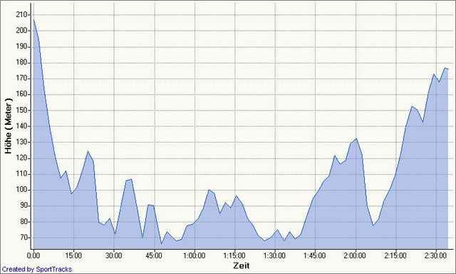
Długość29,8 km Wysokość719 m Way down755 m Czas trwania02:10 h:m Data12.01.2007
Oceny Author User Krajobraz Czynnik zadowolenia Kondycja Technika

Statystyka

1904 Widoki 4 Oceny 319 Downloads / Pliki do pobrania 3.00 Przeciętnie
Rate
  • Karta trasy
  • Dojazd
  • Downloads / Pliki do pobrania
Verbessert die Auermühlen Tour für MTBs!!

Werden sie aber noch weiter verbessern!

Further information at

http://www.mtb-news.de/forum/showthread.php?p=3346287#post3346287

Mapa trasy i profil wysokości

  • Open Street Map
  • Google
Minimum height 57 m Maximum height 217 m Widok szczegółowy

More about the tour author

HitTheDirt

Komentarze

Slayer on 04.02.2007

Keine Daten

Hallo,
wollte die Strecke mal nachfahren (nachdem Ihr meine schlecht bewertet habt), jedoch kann man sie nicht downloaden.
Vielleicht die Tour nochmal neu reinstellen, entweder wenn man mal krank ist oder auf dem Hollandrad fährt.

Hallo

Kannste im Moment eh Knicken Dank Kyrill
Eintracht on 26.09.2007

Tourbewertung

Nette Feierabendrunde mit tollen Trails. Leider hat Kyrill seine Spuren hinterlassen, trotzdem ist die Tour bis auf ein paar Hindernissüberquerungen gut fahrbar. Konditionell eher eine der leichteren Touren.

GPS tracks

Trackpoints
  • GPX / Garmin Map Source (gpx) download
  • TCX / Garmin Training Center® (tcx) download
  • CRS / Garmin Training Center® (crs) download
  • Google Earth (kml) download
  • G7ToWin (g7t) download
  • TTQV (trk) download
  • Overlay (ovl) download
  • Fugawi (txt) download
  • Kompass (DAV) Track (tk) download
  • Karta trasy (pdf) download
  • Original file of the author (gpx) download

More about the tour author

HitTheDirt

Share track
Add to my favorites
Remove from my favorites
Edit tags
My score
Rate
Trasa: Angertrails
Rodzaj: Rower górski (MTB)
Długość: 29,8 km
Evaluated on:
Czas trwania:
Day(s)
Hour(s)
Minute(s)
Ocena: Krajobraz Czynnik zadowolenia Kondycja Technika