Login

Zapomniałeś swój login?

Cookies have to be accepted!
Your browser's cookie functionality is disabled. Please enable this functionality.

Not a member yet?

Register now
Login

Available for registred users only

Log in to use this feature.

Zapomniałeś swój login?

Cookies have to be accepted!
Your browser's cookie functionality is disabled. Please enable this functionality.

Not a member yet?

Register now
Filter
Kategorie
Advanced filters
  • Długość (km)
  • Wysokość
Zapisz filtr Reset filter

TrackRank

QRCode

Technical data

Długość12,8 km Wysokość525 m Way down525 m Czas trwania05:00 h:m Data26.09.2010
Oceny Author Krajobraz Czynnik zadowolenia Kondycja Technika

Statystyka

1532 Widoki 1 Ocena 143 Downloads / Pliki do pobrania 5.00 Przeciętnie
Rate
  • Karta trasy
  • Dojazd
  • Downloads / Pliki do pobrania

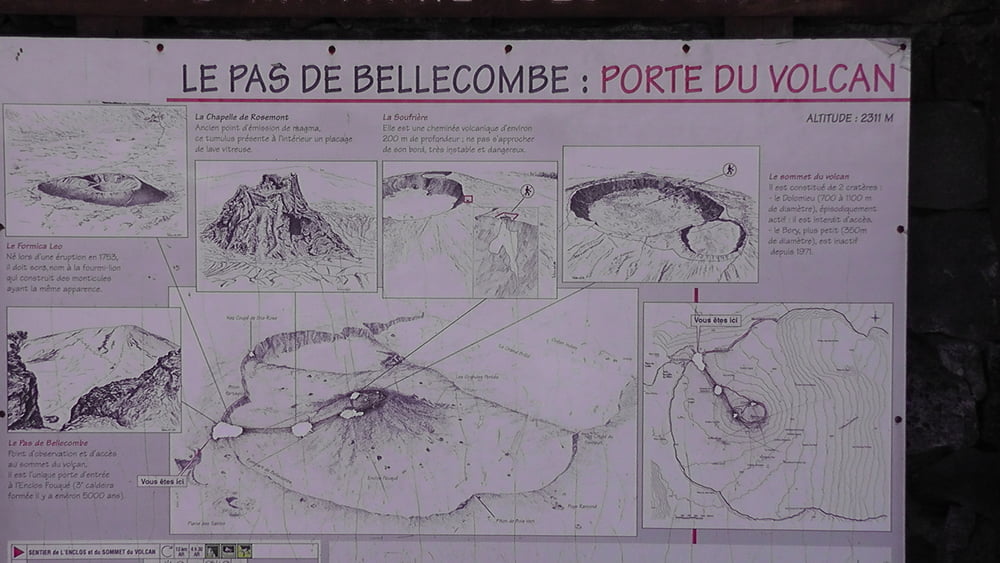
Diese Tour führt von dem Parkplatz in der Nähe des Piton de la Fournaise hinaus auf den Vulkankegel. Leider zieht Mittags meistens Nebel auf so das die Sicht nicht mehr so toll war.

Further information at

http://www.fournaise.info/

Galeria trasy

Mapa trasy i profil wysokości

  • Open Street Map
  • Google
Minimum height 2227 m Maximum height 2501 m Widok szczegółowy

More about the tour author

Joachimr
Member since 2009

Send private message

Komentarze

Von Bourg Mourat dem Weg "Route de Volcan" folgen und am Ende befindet sich ein Parkplatz.

GPS tracks

Trackpoints
  • GPX / Garmin Map Source (gpx) download
  • TCX / Garmin Training Center® (tcx) download
  • CRS / Garmin Training Center® (crs) download
  • Google Earth (kml) download
  • G7ToWin (g7t) download
  • TTQV (trk) download
  • Overlay (ovl) download
  • Fugawi (txt) download
  • Kompass (DAV) Track (tk) download
  • Karta trasy (pdf) download
  • Original file of the author (gpx) download

More about the tour author

Joachimr
Member since 2009

Send private message
Share track
Add to my favorites
Remove from my favorites
Edit tags
My score
Rate
Trasa: La Reunion Aufstieg zum Piton de la Fournaise
Rodzaj: Wędrówki
Długość: 12,8 km
Evaluated on:
Czas trwania:
Day(s)
Hour(s)
Minute(s)
Ocena: Krajobraz Czynnik zadowolenia Kondycja Technika