


Die Tour führt hauptsächlich über unbefahrene asphaltierte Wege. Vom Marbachjoch aus führt die Route ca. 2km über einen Wanderweg. Die Steigungen sind moderat. Daher ist die Tour auch für Anfänger geeignet und ggf. auch mit einem Trekkingrad befahrbar.
Start ist an der Bahn zum Marbachjoch in Niederau.
Start ist an der Bahn zum Marbachjoch in Niederau.
Further information at
http://www.wildschoenau.atGaleria trasy
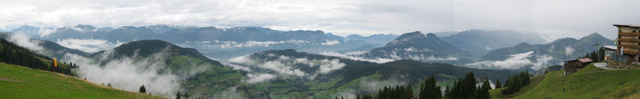
Mapa trasy i profil wysokości
Minimum height 824 m
Maximum height 1479 m
More about the tour author

|
chr.paisys |
Komentarze
Auf der Inntalautobahn A12 Ausfahrt Wörgl. In Wörgl der Beschilderung Wildschönau folgen.
In Niederau links Richtung Pesendorf abbiegen und der Beschilderung zur Marbachjochbahn folgen.
In Niederau links Richtung Pesendorf abbiegen und der Beschilderung zur Marbachjochbahn folgen.
GPS tracks
Trackpoints-
GPX / Garmin Map Source (gpx) download
-
TCX / Garmin Training Center® (tcx) download
-
CRS / Garmin Training Center® (crs) download
-
Google Earth (kml) download
-
G7ToWin (g7t) download
-
TTQV (trk) download
-
Overlay (ovl) download
-
Fugawi (txt) download
-
Kompass (DAV) Track (tk) download
-
Karta trasy (pdf) download
-
Original file of the author (gpx) download
More about the tour author
|
|
chr.paisys |
Add to my favorites
Remove from my favorites
Edit tags
Open track
My score
Rate
Sehr schoene Tour - auch gegen den Uhrzeigersinn!!