

Marathon Rennen mit 34Km (kurz 2 Runden ca. 725 Hm) oder 66Km (Langdistanz 4 Runden ca. 1450 Hm) rund um den Katzenbuckel (626m).
Bei trockenem Wetter ein schnelles abwechlungsreicher Kurs. Bei Nässe kann es gerade bei den vielen wurzligen Trails zu einer Rutschpartie werden.
ACHTUNG! Da es ein zu 50% extra abgesteckter Kurs ist, kann man diesen zu einem späteren Zeitpunkt nicht fahren, da es keine offiziellen Waldwege sind. Darauf bitte ich Rücksicht zu nehmen.
Further information at
http://www.mtb-waldkatzenbach.de/index.php?option=content&task=blogcategory&id=39&Itemid=86Galeria trasy

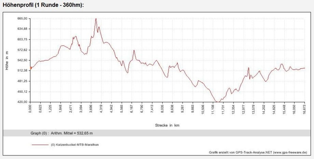
Mapa trasy i profil wysokości
Minimum height 420 m
Maximum height 623 m
More about the tour author
|
|
ossinator |
Komentarze

GPS tracks
Trackpoints-
GPX / Garmin Map Source (gpx) download
-
TCX / Garmin Training Center® (tcx) download
-
CRS / Garmin Training Center® (crs) download
-
Google Earth (kml) download
-
G7ToWin (g7t) download
-
TTQV (trk) download
-
Overlay (ovl) download
-
Fugawi (txt) download
-
Kompass (DAV) Track (tk) download
-
Karta trasy (pdf) download
-
Original file of the author (gpx) download
More about the tour author
|
|
ossinator |
Add to my favorites
Remove from my favorites
Edit tags
Open track
My score
Rate