Login

Zapomniałeś swój login?

Cookies have to be accepted!
Your browser's cookie functionality is disabled. Please enable this functionality.

Not a member yet?

Register now
Login

Available for registred users only

Log in to use this feature.

Zapomniałeś swój login?

Cookies have to be accepted!
Your browser's cookie functionality is disabled. Please enable this functionality.

Not a member yet?

Register now
Filter
Kategorie
Advanced filters
  • Długość (km)
  • Wysokość
Zapisz filtr Reset filter

TrackRank

QRCode

Technical data

Długość124,6 km Wysokość1421 m Way down1418 m Czas trwania05:00 h:m Data03.06.2007
Oceny Author User Krajobraz Czynnik zadowolenia Kondycja Technika

Statystyka

9906 Widoki 1 Ocena 777 Downloads / Pliki do pobrania 4.00 Przeciętnie
Rate
  • Karta trasy
  • Dojazd
  • Downloads / Pliki do pobrania
Tolle RTF vom Vereinsheim in Ludwigsburg durch Weinberg und Wälder.
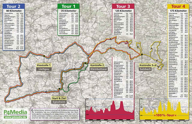
Mir haben heute die 125 km gereicht.
Es gibt noch eine erweiterte Strecke von 175 km.
Vieleicht stellt die ein anderer Teilnehmer online.

Further information at

http://www.rsc-komet.de

Mapa trasy i profil wysokości

  • Open Street Map
  • Google
Minimum height 176 m Maximum height 510 m Widok szczegółowy

More about the tour author

scott_99
Member since 2006

Send private message

Komentarze

piamaus1 on 31.05.2014

barockrundfahrt

xy
A81 - Abfahrt Ludwigsburg

GPS tracks

Trackpoints
  • GPX / Garmin Map Source (gpx) download
  • TCX / Garmin Training Center® (tcx) download
  • CRS / Garmin Training Center® (crs) download
  • Google Earth (kml) download
  • G7ToWin (g7t) download
  • TTQV (trk) download
  • Overlay (ovl) download
  • Fugawi (txt) download
  • Kompass (DAV) Track (tk) download
  • Karta trasy (pdf) download
  • Original file of the author (gpx) download

More about the tour author

scott_99
Member since 2006

Send private message
Share track
Add to my favorites
Remove from my favorites
Edit tags
My score
Rate
Trasa: RTF - Barockrundfahrt Ludwigsburg 2007 - 125 km
Rodzaj: Rower szosowy
Długość: 124,6 km
Evaluated on:
Czas trwania:
Day(s)
Hour(s)
Minute(s)
Ocena: Krajobraz Czynnik zadowolenia Kondycja Technika