Login

Zapomniałeś swój login?

Cookies have to be accepted!
Your browser's cookie functionality is disabled. Please enable this functionality.

Not a member yet?

Register now
Login

Available for registred users only

Log in to use this feature.

Zapomniałeś swój login?

Cookies have to be accepted!
Your browser's cookie functionality is disabled. Please enable this functionality.

Not a member yet?

Register now
Filter
Kategorie
Advanced filters
  • Długość (km)
  • Wysokość
Zapisz filtr Reset filter

TrackRank

QRCode

Technical data

Długość50,3 km Wysokość2567 m Way down1616 m Czas trwania1 day 0 h Data09.10.2011
Oceny Author Krajobraz Czynnik zadowolenia Kondycja Technika

Statystyka

499 Widoki 1 Ocena 38 Downloads / Pliki do pobrania 1.00 Przeciętnie
Rate
  • Karta trasy
  • Dojazd
  • Downloads / Pliki do pobrania

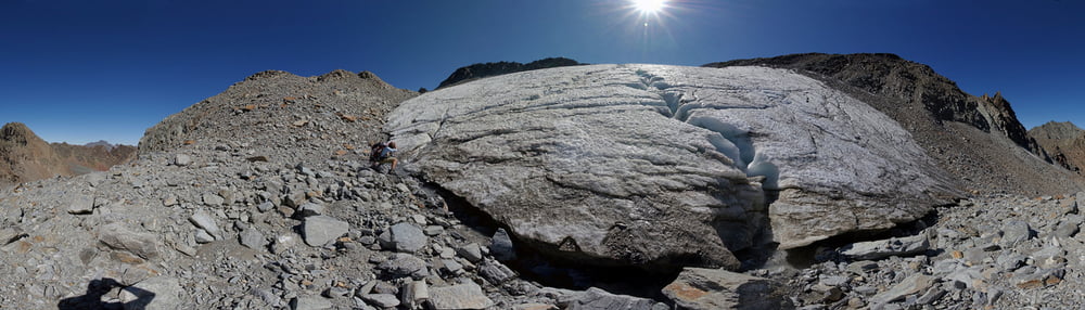
Von Winnebach mit dem Bike einen Km hinter die Ambergerhütte, weiter zu Fuß und die letzten Meter mit Steigeisen über den kleinen Gletscher http://www.alpen-panoramen.de/panorama.php?pid=16681 und leichtes kraxeln auf den Gipfel.

Gerade sehe ich das der logger nicht abgeschaltet war, die Tour beginnt und endet ab Winnebach.

Galeria trasy

Mapa trasy i profil wysokości

  • Open Street Map
  • Google
Minimum height 684 m Maximum height 3244 m Widok szczegółowy

More about the tour author

Siesei
Member since 2011

Send private message

Komentarze


Am Ende von Winnebach ist ein Parkplatz


GPS tracks

Trackpoints
  • GPX / Garmin Map Source (gpx) download
  • TCX / Garmin Training Center® (tcx) download
  • CRS / Garmin Training Center® (crs) download
  • Google Earth (kml) download
  • G7ToWin (g7t) download
  • TTQV (trk) download
  • Overlay (ovl) download
  • Fugawi (txt) download
  • Kompass (DAV) Track (tk) download
  • Karta trasy (pdf) download
  • Original file of the author (gpx) download

More about the tour author

Siesei
Member since 2011

Send private message
Share track
Add to my favorites
Remove from my favorites
Edit tags
My score
Rate
Trasa: Kuhscheibe
Rodzaj: Trasy górskie
Długość: 50,3 km
Evaluated on:
Czas trwania:
Day(s)
Hour(s)
Minute(s)
Ocena: Krajobraz Czynnik zadowolenia Kondycja Technika