

This great ride begins at the Spooner Lake day use area in the Lake Tahoe Nevada State Park on the east side of Lake Tahoe. Look for signs leading you to the Flume Trail from this parking area via the North Canyon Road. This road runs past the old sheperd's hut, then gives way to rolling uphill terrain through beautiful aspen groves that thrive in the Carson Range on the east side of Lake Tahoe.
The half mile of climbing past Snow Valley is where you become friendly with that shiny little granny gear on your mountain bike. You start the ride at 7000' and climb to 8157' giving you only 1100' to climb so take your time and savor these ascents as they are the only ones you'll do all day. We know you want the full Tahoe mountain bike experience.
At the summit, a quick break under the whispering lodge pole pines quickly dries the sweat and refreshes the soul.
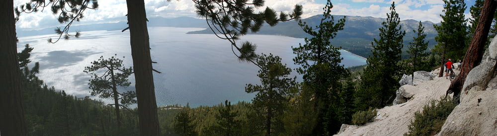
Next a short descent leads to the peaceful, pristine Marlette Lake (pictured). In the fall the colors at Marlette Lake are a site to behold. A mile and a half of riding on the dirt road along the shore of this beautiful lake leads to the incredible Flume Trail.
The Flume Trail is nearly flat, dropping only 40' per mile and is spectacular in its setting. 1600' above the east shore of Lake Tahoe and only a half mile away from the shoreline in places, it is truly one of the the premier trails in the world. Stop often and enjoy the view. Take something to eat and drink for an unforgettable picnic.
At the end of the Flume Trail, there is a 3 mile, 1600' descent down to Highway 28.
The Flume Trail is a moderately difficult ride at 7000' to 8000' feet in elevation with over a 1000' of climbing and 4.5 miles of single track. The Flume Trail itself traverses above several steep sections, so those afraid of heights be forewarned. In this world, most spectacular vistas require traversing steep terrain.
Galeria trasy
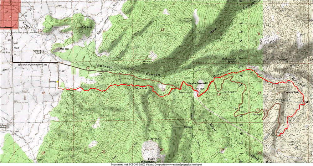
Mapa trasy i profil wysokości
Minimum height 2122 m
Maximum height 2650 m
More about the tour author

|
happyfloh |
Komentarze

GPS tracks
Trackpoints-
GPX / Garmin Map Source (gpx) download
-
TCX / Garmin Training Center® (tcx) download
-
CRS / Garmin Training Center® (crs) download
-
Google Earth (kml) download
-
G7ToWin (g7t) download
-
TTQV (trk) download
-
Overlay (ovl) download
-
Fugawi (txt) download
-
Kompass (DAV) Track (tk) download
-
Karta trasy (pdf) download
-
Original file of the author (gpx) download
More about the tour author
|
|
happyfloh |
Add to my favorites
Remove from my favorites
Edit tags
Open track
My score
Rate