

Offizielle Mountainbikeroute Nr. 1 von Appenzellerland Tourismus AI
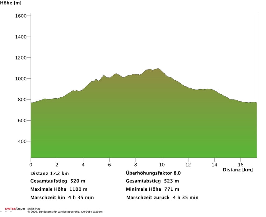
Die Tour führt über die Ochsenegg, Eischen, Kaubad, Lemerenwees, Gontenbad, zurück nach Appenzell.
Wunderschöne aber nicht allzu anspruchsvolle Tour über Appenzell.
Diese Tour lässt sich gut mit der Offiziellen Mountainbikeroute Nr. 2 erweitern! Verpflegen kann man sich im Landgasthof Eischen (www.eischen.ch) oder im Hotel-Restaurant Kaubad (www.kaubad.ch).
Geführte Touren - Bike mieten - Bikeurlaub in Appenzell:
http://www.bike-appenzellerland.ch
GPS-Touren in der Schweiz:
http://www.gps-touren.ch
GPS-Daten in beliebiges Format konvertieren:
http://www.gpsies.com/upload.do?uploadMode=convert
Further information at
http://www.bike-appenzellerland.chMapa trasy i profil wysokości
Minimum height 99999 m
Maximum height -99999 m
More about the tour author

|
jeki |
Komentarze

Tourstart ist beim Brauereiplatz in Appenzell.
GPS tracks
Trackpoints-
GPX / Garmin Map Source (gpx) download
-
TCX / Garmin Training Center® (tcx) download
-
CRS / Garmin Training Center® (crs) download
-
Google Earth (kml) download
-
G7ToWin (g7t) download
-
TTQV (trk) download
-
Overlay (ovl) download
-
Fugawi (txt) download
-
Kompass (DAV) Track (tk) download
-
Karta trasy (pdf) download
-
Original file of the author (gpx) download
More about the tour author
|
|
jeki |
Add to my favorites
Remove from my favorites
Edit tags
Open track
My score
Rate