Login

Si pozabil/a podatke za prijavo?

Cookies have to be accepted!
Your browser's cookie functionality is disabled. Please enable this functionality.

Not a member yet?

Register now
Login

Available for registred users only

Log in to use this feature.

Si pozabil/a podatke za prijavo?

Cookies have to be accepted!
Your browser's cookie functionality is disabled. Please enable this functionality.

Not a member yet?

Register now
Filter
Kategorije
Advanced filters
  • Dolžina (km)
  • Metri nadmorske višine
Shrani filter Reset filter

TrackRank

QRCode

Technical data

Dolžina5,6 km Metri nadmorske višine831 m Way down844 m Trajanje04:15 h:m Datum26.10.2013
Ocene Author Pokrajina Dejavnik zabave Kondicija Tehnika

Statistika

521 Pogledi Ocene 20 Prenosi Povprečje
Rate
  • List z izleti
  • Prihod
  • Prenosi

Aufstieg: 02Std.50min.

Absteig: 01Std. 25min.

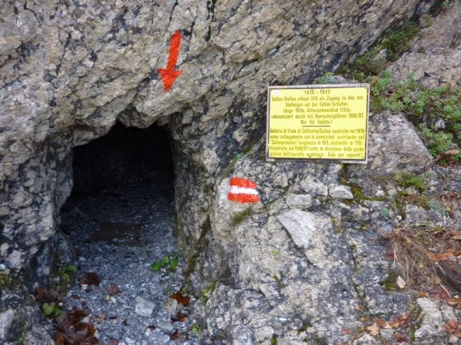
ferrata senza confine über den Stollen.

Galerija izletov

Zemljevid in višinski profil izleta

  • Open Street Map
  • Google
Minimum height 1358 m Maximum height 2206 m Prikaz podrobnosti

More about the tour author

harald07071
Member since 2008

Send private message

Komentarji

Kötschach-Mauthen ist erreichbar über die A 2, Ausfahrt Arnoldstein und weiter über Hermagor auf der Bundesstraße 111. Oder aus dem Raum Lienz von Oberdrauburg auf der Bundesstraße 110 über den Gailbergsattel.
Von Kötschach-Mauthen fährt man auf der B 110 weiter auf den Plöckenpass.


Poti GPS

Trackpoints
  • GPX / Garmin Map Source (gpx) download
  • TCX / Garmin Training Center® (tcx) download
  • CRS / Garmin Training Center® (crs) download
  • Google Earth (kml) download
  • G7ToWin (g7t) download
  • TTQV (trk) download
  • Overlay (ovl) download
  • Fugawi (txt) download
  • Kompass (DAV) Track (tk) download
  • List z izleti (pdf) download
  • Original file of the author (gpx) download

More about the tour author

harald07071
Member since 2008

Send private message
Share track
Add to my favorites
Remove from my favorites
Edit tags
My score
Rate
Izlet: Cellon (2241m)
Vrsta: Plezalna pot
Dolžina: 5,6 km
Evaluated on:
Trajanje:
Day(s)
Hour(s)
Minute(s)
Ocena: Pokrajina Dejavnik zabave Kondicija Tehnika