Login

Si pozabil/a podatke za prijavo?

Cookies have to be accepted!
Your browser's cookie functionality is disabled. Please enable this functionality.

Not a member yet?

Register now
Login

Available for registred users only

Log in to use this feature.

Si pozabil/a podatke za prijavo?

Cookies have to be accepted!
Your browser's cookie functionality is disabled. Please enable this functionality.

Not a member yet?

Register now
Filter
Kategorije
Advanced filters
  • Dolžina (km)
  • Metri nadmorske višine
Shrani filter Reset filter

TrackRank

QRCode

Technical data

Dolžina30,3 km Metri nadmorske višine139 m Way down139 m Trajanje01:30 h:m Datum27.05.2014
Ocene Author Pokrajina Dejavnik zabave Kondicija Tehnika

Statistika

113 Pogledi Ocene 8 Prenosi Povprečje
Rate
  • List z izleti
  • Prihod
  • Prenosi

Mit den Kumpels zur Anmeldung des Velotons durch die Stadt.

Immer wieder schön jemand die schöne Stadt zu zeigen.


Further information at

http://www.garmin-velothon-berlin.de/

Galerija izletov

Zemljevid in višinski profil izleta
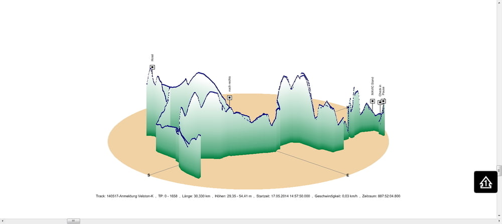
  • Open Street Map
  • Google
Minimum height 29 m Maximum height 54 m Prikaz podrobnosti

More about the tour author

Pheinz
Member since 2009

Send private message

Komentarji

Einstieg an beliebiger Stelle

Poti GPS

Trackpoints
  • GPX / Garmin Map Source (gpx) download
  • TCX / Garmin Training Center® (tcx) download
  • CRS / Garmin Training Center® (crs) download
  • Google Earth (kml) download
  • G7ToWin (g7t) download
  • TTQV (trk) download
  • Overlay (ovl) download
  • Fugawi (txt) download
  • Kompass (DAV) Track (tk) download
  • List z izleti (pdf) download
  • Original file of the author (gpx) download

More about the tour author

Pheinz
Member since 2009

Send private message
Share track
Add to my favorites
Remove from my favorites
Edit tags
My score
Rate
Izlet: Anmeldung Veloton
Vrsta: Izleti s kolesom
Dolžina: 30,3 km
Evaluated on:
Trajanje:
Day(s)
Hour(s)
Minute(s)
Ocena: Pokrajina Dejavnik zabave Kondicija Tehnika