Login

Si pozabil/a podatke za prijavo?

Cookies have to be accepted!
Your browser's cookie functionality is disabled. Please enable this functionality.

Not a member yet?

Register now
Login

Available for registred users only

Log in to use this feature.

Si pozabil/a podatke za prijavo?

Cookies have to be accepted!
Your browser's cookie functionality is disabled. Please enable this functionality.

Not a member yet?

Register now
Filter
Kategorije
Advanced filters
  • Dolžina (km)
  • Metri nadmorske višine
Shrani filter Reset filter

TrackRank

QRCode

Technical data

Dolžina22,4 km Metri nadmorske višine1297 m Way down411 m Trajanje03:00 h:m Datum15.05.2015
Ocene Author Pokrajina Dejavnik zabave Kondicija Tehnika

Statistika

200 Pogledi Ocene 33 Prenosi Povprečje
Rate
  • List z izleti
  • Prihod
  • Prenosi

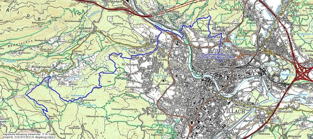
Wie alle meine Touren, höchst mögliche Asphaltvermeidung....


Die Tour führt über einen Teil des Oswaldiberges (Trailabfahrt in den Aichholzgraben) über die Drau - Staumauer in die obere Fellach - Kneipp Wiese - St. Georgen - Variante (steil) auf den Hundsmarhof und über Heiligengeist auf die Kaserin...

Dort hat mich das schlechte Wetter eingeholt, und ich musste abbrechen. 

Die Abfahrt wäre vielfältig, und ist über andere Touren zur Genüge beschrieben...


Zemljevid in višinski profil izleta

  • Open Street Map
  • Google
Minimum height 494 m Maximum height 1409 m Prikaz podrobnosti

More about the tour author

johnatan
Member since 2009

Send private message

Komentarji


Start ist in Villach Lind / Treffner Straße


Poti GPS

Trackpoints
  • GPX / Garmin Map Source (gpx) download
  • TCX / Garmin Training Center® (tcx) download
  • CRS / Garmin Training Center® (crs) download
  • Google Earth (kml) download
  • G7ToWin (g7t) download
  • TTQV (trk) download
  • Overlay (ovl) download
  • Fugawi (txt) download
  • Kompass (DAV) Track (tk) download
  • List z izleti (pdf) download
  • Original file of the author (gpx) download

More about the tour author

johnatan
Member since 2009

Send private message
Share track
Add to my favorites
Remove from my favorites
Edit tags
My score
Rate
Izlet: Verlängerte Auffahrt Kaserin
Vrsta: Gorsko kolo
Dolžina: 22,4 km
Evaluated on:
Trajanje:
Day(s)
Hour(s)
Minute(s)
Ocena: Pokrajina Dejavnik zabave Kondicija Tehnika