Login

Si pozabil/a podatke za prijavo?

Cookies have to be accepted!
Your browser's cookie functionality is disabled. Please enable this functionality.

Not a member yet?

Register now
Login

Available for registred users only

Log in to use this feature.

Si pozabil/a podatke za prijavo?

Cookies have to be accepted!
Your browser's cookie functionality is disabled. Please enable this functionality.

Not a member yet?

Register now
Filter
Kategorije
Advanced filters
  • Dolžina (km)
  • Metri nadmorske višine
Shrani filter Reset filter

TrackRank

QRCode

Technical data

Dolžina1,3 km Metri nadmorske višine28 m Way down47 m Trajanje01:00 h:m Datum27.08.2017
Ocene Author Pokrajina Dejavnik zabave Kondicija Tehnika

Statistika

170 Pogledi Ocene 16 Prenosi Povprečje
Rate
  • List z izleti
  • Prihod
  • Prenosi
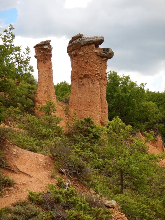
A nice place with earth pyramids. I can’t find it on a map. Easy to walk, but much stairs.

Galerija izletov

Zemljevid in višinski profil izleta

  • Open Street Map
  • Google
Minimum height 728 m Maximum height 774 m Prikaz podrobnosti

More about the tour author

Mapdekode
Member since 2008

Send private message

Komentarji

You can reach it from Mikrovalto, on a small paved road. There are no signs on the road near Mikrovalto.

Poti GPS

Trackpoints
  • GPX / Garmin Map Source (gpx) download
  • TCX / Garmin Training Center® (tcx) download
  • CRS / Garmin Training Center® (crs) download
  • Google Earth (kml) download
  • G7ToWin (g7t) download
  • TTQV (trk) download
  • Overlay (ovl) download
  • Fugawi (txt) download
  • Kompass (DAV) Track (tk) download
  • List z izleti (pdf) download
  • Original file of the author (gpx) download

More about the tour author

Mapdekode
Member since 2008

Send private message
Share track
Add to my favorites
Remove from my favorites
Edit tags
My score
Rate
Izlet: Greece, Kozani: Earth pyramids Bouharia
Vrsta: Pešačenje
Dolžina: 1,3 km
Evaluated on:
Trajanje:
Day(s)
Hour(s)
Minute(s)
Ocena: Pokrajina Dejavnik zabave Kondicija Tehnika