

Die Wanderung startet am Richardhof (Golfclub, Restaurant und Reitstall).
Rechts am Teich vorbei, beginnt der Wanderweg hinter dem Richardhof, vor der großen Golfwiese. Ich folge dem breiten Wanderweg (Forststraße) bis zur Gedenktafel der "Breite Föhre".
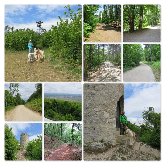
Nun biege ich nach links ab und folge der Anningerstraße bergan. Rechterhand passiere ich das Gasthaus "Krauste Linde" und einige hundert Meter weiter eine Quelle mit Überlauf.
Bald darauf komme ich zum Anningerhaus und nehme den Wanderweg rechts davor nach hinten zur Jubiläumswarte.
Die Jubiläumswarte ist derzeit aus baulichen Gründen geschlossen/versperrt und ein Betreten nicht möglich!
Also drehe ich um, gehe am Anningerhaus vorbei und komme alsbald zur Wilhelmswarte.
Oben auf dem Steinturm der Wilhelmswarte geht ein sehr kräftiger Wind, es gibt aber eine schöne Aussicht unter anderem zum Leithagebirge und zum Schneeberg.
Nun folge ich dem Steig bergab bis zum Beethoven Wanderweg und folge diesem zurück bis zum Richardhof.
Further information at
https://www.kraustelinde.net/Zemljevid in višinski profil izleta
Minimum height 322 m
Maximum height 675 m
More about the tour author
|
|
huberj59 |
Komentarji

Parkplatz am Richardhof. Koordinaten: N48 03 22.1 E16 16 30.6
Poti GPS
Trackpoints-
GPX / Garmin Map Source (gpx) download
-
TCX / Garmin Training Center® (tcx) download
-
CRS / Garmin Training Center® (crs) download
-
Google Earth (kml) download
-
G7ToWin (g7t) download
-
TTQV (trk) download
-
Overlay (ovl) download
-
Fugawi (txt) download
-
Kompass (DAV) Track (tk) download
-
List z izleti (pdf) download
-
Original file of the author (gpx) download
More about the tour author
|
|
huberj59 |
Add to my favorites
Remove from my favorites
Edit tags
Open track
My score
Rate