
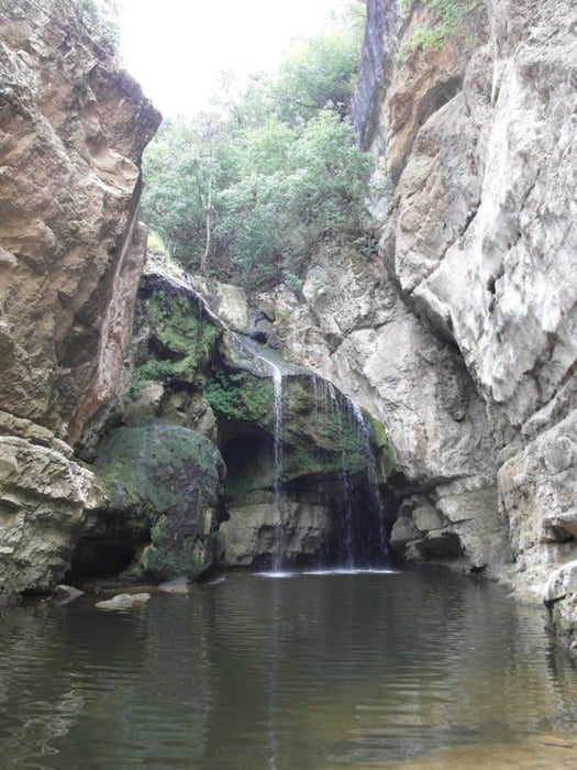

Diese Tour führt vom unteren See, an dem zwei Cafés liegen, zum Wasserfall.
Sie ist eine Mini-Wanderung (wenngleich nicht länger als ein Spaziergang) in der Schlucht. Einige Passagen sind befestigt, aber es ist keinerlei Ausrüstung nötig. Einheimische gehen die Tour mit Flip-Flops, das würde ich allerdings nicht machen. Man kann die Schlucht nicht weiter aufwärts gehen, höchstens richtige Kletterer.
In der Schlucht hatten mein Handy offenbar Probleme mit dem GPS, deshalb passt der Track nicht ganz.
Anfahrt von der Nationalstraße M 9-1 zwischen Klina und Gjakova, dann 3-4 Kilometer auf der Schotterpiste zum "Parkplatz".
Zemljevid in višinski profil izleta
Minimum height 383 m
Maximum height 454 m
More about the tour author

|
Rum2014 |
Komentarji

Anfahrt von der Nationalstraße M 9-1 zwischen Klina und Gjakova, dann 3-4 Kilometer auf der Schotterpiste zum "Parkplatz".
Poti GPS
Trackpoints-
GPX / Garmin Map Source (gpx) download
-
TCX / Garmin Training Center® (tcx) download
-
CRS / Garmin Training Center® (crs) download
-
Google Earth (kml) download
-
G7ToWin (g7t) download
-
TTQV (trk) download
-
Overlay (ovl) download
-
Fugawi (txt) download
-
Kompass (DAV) Track (tk) download
-
List z izleti (pdf) download
-
Original file of the author (gpx) download
More about the tour author
|
|
Rum2014 |
Add to my favorites
Remove from my favorites
Edit tags
Open track
My score
Rate