
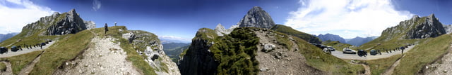

9 Tage rund um die Dolomiten. Von einem Pass zum anderen. Wunderschöne Landschaft und Kurven ohne ende. Die Tour hatten wir gut geplant und es hat sich wirklich gelohnt.
Fragen beantworte ich gerne..
Galerija izletov


Zemljevid in višinski profil izleta
Minimum height 98 m
Maximum height 2568 m
More about the tour author

|
mad4bad |
Komentarji

Vollgas bis in die Alpen und nie schneller als möglich :-)
Poti GPS
Trackpoints-
GPX / Garmin Map Source (gpx) download
-
TCX / Garmin Training Center® (tcx) download
-
CRS / Garmin Training Center® (crs) download
-
Google Earth (kml) download
-
G7ToWin (g7t) download
-
TTQV (trk) download
-
Overlay (ovl) download
-
Fugawi (txt) download
-
Kompass (DAV) Track (tk) download
-
List z izleti (pdf) download
-
Original file of the author (gpx) download
More about the tour author
|
|
mad4bad |
Add to my favorites
Remove from my favorites
Edit tags
Open track
My score
Rate