Login

Si pozabil/a podatke za prijavo?

Cookies have to be accepted!
Your browser's cookie functionality is disabled. Please enable this functionality.

Not a member yet?

Register now
Login

Available for registred users only

Log in to use this feature.

Si pozabil/a podatke za prijavo?

Cookies have to be accepted!
Your browser's cookie functionality is disabled. Please enable this functionality.

Not a member yet?

Register now
Filter
Kategorije
Advanced filters
  • Dolžina (km)
  • Metri nadmorske višine
Shrani filter Reset filter

TrackRank

QRCode

Technical data

Dolžina6,1 km Metri nadmorske višine224 m Way down223 m Trajanje03:00 h:m Datum11.04.2006
Ocene Author User Pokrajina Dejavnik zabave Kondicija Tehnika

Statistika

12949 Pogledi 3 Ocene 723 Prenosi 4.00 Povprečje
Rate
  • List z izleti
  • Prihod
  • Prenosi
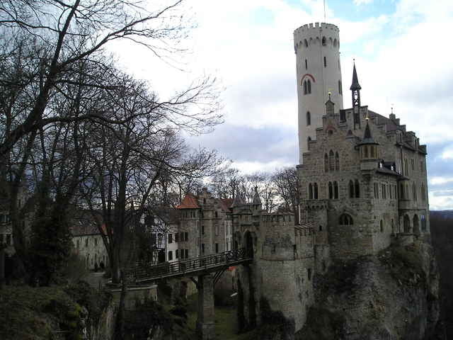
Von Parkplatz Kalkhofenhütte geht nach ca. 200m zur Höhle Goldloch. Danach weiter zur Aussichtfelsen Gießstein. Richtung Schloss Lichtenstein passieren wir an der Talkante entlang weitere Aussichtpunkte, kreuzen einen Hohlweg, die Schlosssteige, und einige Minuten später vor Schloss Lichtenstein. Nach der Schlossbesichtigung folgen wir einen Fahrweg direkt zur Parkplatz Kalkhofenhütte.

Further information at

http://www.schloss-lichtenstein.de/

Galerija izletov

Zemljevid in višinski profil izleta

  • Open Street Map
  • Google
Minimum height 700 m Maximum height 781 m Prikaz podrobnosti

More about the tour author

Bernd
Member since 2005

Send private message

Komentarji

AlbtraufJochen on 08.08.2009

Albtrauf Honau

vielen Dank, eine wirklich schöne Tour. Mittlerweile hat sich am Weg nahe des Schlosses ein Hochseilklettergarten angesiedelt. Bemwerkenwert ist auch die Höhle Goldloch, etwa 100 m nördlich der Kalkofenhütte.
PKW: Von Reutlingen B312 über Pfullingen nach Unterhausen. Vor Ortsausgang rechts abbiegen (Schild "Sportplatz") und hochfahren bis auf der Alb der Parkplatz Kalkhofen.

Poti GPS

Trackpoints
  • GPX / Garmin Map Source (gpx) download
  • TCX / Garmin Training Center® (tcx) download
  • CRS / Garmin Training Center® (crs) download
  • Google Earth (kml) download
  • G7ToWin (g7t) download
  • TTQV (trk) download
  • Overlay (ovl) download
  • Fugawi (txt) download
  • Kompass (DAV) Track (tk) download
  • List z izleti (pdf) download
  • Original file of the author (gpx) download

More about the tour author

Bernd
Member since 2005

Send private message
Share track
Add to my favorites
Remove from my favorites
Edit tags
My score
Rate
Izlet: Romantische Schloss Lichtenstein
Vrsta: Pešačenje
Dolžina: 6,1 km
Evaluated on:
Trajanje:
Day(s)
Hour(s)
Minute(s)
Ocena: Pokrajina Dejavnik zabave Kondicija Tehnika