
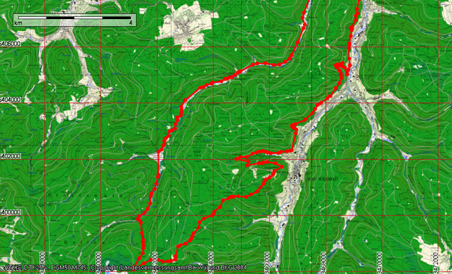

Eyachbrücke auf dem normalen Fahrweg zur Eyachmühle, Brotenbach, Rotwasserhütte immer dem Rotwasserbach folgen, Weißensteinhütte, Grünhütte
Zurück über den Mittelweg an den 5 Bäume vorbei zum Sommerberg, Zick-Zack-Weg bis zum ersten Schotterquerweg, links bergab über die Fahrstraße queren und dann bergauf bis zum Rennbachtal, Wanderweg downhill bis zum Köpflesbrunnen, Hangquerung auf schmalem Trail und auf Forstwegen bis Calmbach, Radweg bis zur Eyachbrücke
Zurück über den Mittelweg an den 5 Bäume vorbei zum Sommerberg, Zick-Zack-Weg bis zum ersten Schotterquerweg, links bergab über die Fahrstraße queren und dann bergauf bis zum Rennbachtal, Wanderweg downhill bis zum Köpflesbrunnen, Hangquerung auf schmalem Trail und auf Forstwegen bis Calmbach, Radweg bis zur Eyachbrücke
Galerija izletov
Zemljevid in višinski profil izleta
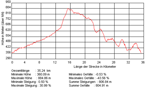
Minimum height 99999 m
Maximum height 2147483647 m
More about the tour author
|
|
siggi.k. |
Komentarji

Zwischen Neuenbürg und Höfen von der Bundesstraße rechts Richtung Dobel, nach dem Bahnübergang links abbiegen. Wenn man links weiterfährt, kann man auch nach der Eyachbrücke auf der rechten Seite parken
Poti GPS
Trackpoints-
GPX / Garmin Map Source (gpx) download
-
TCX / Garmin Training Center® (tcx) download
-
CRS / Garmin Training Center® (crs) download
-
Google Earth (kml) download
-
G7ToWin (g7t) download
-
TTQV (trk) download
-
Overlay (ovl) download
-
Fugawi (txt) download
-
Kompass (DAV) Track (tk) download
-
List z izleti (pdf) download
-
Original file of the author (g7t) download
More about the tour author
|
|
siggi.k. |
Add to my favorites
Remove from my favorites
Edit tags
Open track
My score
Rate