

Deutsche Beschreibung siehe unten
Una vuelta en bici de monte corta y muy divertida. Se sube desde Zarautz hacia el parque de pagoeta. Se puede dar la vuelta en ambas directiones.
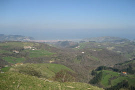
Ariba hay unas vistas muy bonitas hacia el interior tanto como a´la costa viendo Zarautz y Getaria.
La vuelta tarde entre 1,5 horas y 2,5 horas dependiendo de la condocion que tengas.
A pasarlo bien!
Eine schöne Mountainbiketour, kurz und knackig. Gestartet wird von Zarautz in Richtung Pagoeta Nationalpark. Die Route kann locker in beide Richtungen gefahren weren.
Oben wird man durch eine wunderschönes Aussicht ins Landesinnere sowie in Richtung Küste belohnt, wobei man Getaria und Zarautz bewundern kann.
Die Tour dauert zwischen 1,5 und 2,5 Stunden, abhängig von der Kondition.
Viel Spass!
Further information at
http://www.zarautz.comZemljevid in višinski profil izleta
Minimum height -9 m
Maximum height 678 m
More about the tour author

|
christophpreker |
Komentarji

Zarautz hat nur eine Brücke über die Autobahn, hier kann gestartet werden, die andere Richtung geht aus dem Gewerbegebiet los!
Poti GPS
Trackpoints-
GPX / Garmin Map Source (gpx) download
-
TCX / Garmin Training Center® (tcx) download
-
CRS / Garmin Training Center® (crs) download
-
Google Earth (kml) download
-
G7ToWin (g7t) download
-
TTQV (trk) download
-
Overlay (ovl) download
-
Fugawi (txt) download
-
Kompass (DAV) Track (tk) download
-
List z izleti (pdf) download
-
Original file of the author (gpx) download
More about the tour author
|
|
christophpreker |
Add to my favorites
Remove from my favorites
Edit tags
Open track
My score
Rate