
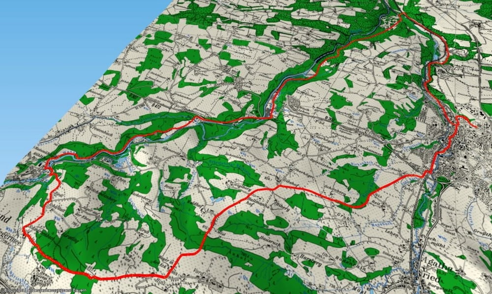

Kleine Frühjahrstour in den Hügeln rund um Miesbach auf schmalen Teerstrassen und Forstwegen. Ein kurzer aber feiner Trail hinunter nach Schwärzenbach. Schöne Fahrt entlang der Mangfall zurück nach Miesbach. Wermutstropfen: ca. 1,3 km leicht bergab auf der B472.
Einkehr: keine an der Route; evtl. kurz vor der Mangfallbrücke von der B472 links leicht bergauf ca. 1 km nach Wall zum Gasthaus an der Kirche.
Galerija izletov
Zemljevid in višinski profil izleta
Minimum height 548 m
Maximum height 767 m
More about the tour author

|
mfa69 |
Komentarji
Von München kommend über die A8 Richtung Salzburg bis zur Ausfahrt Weyern. Dort rechts bis Miesbach. Kurz nach dem Ortseingang ( bei OBI ) rechts - eigentlich parken beim Sportzentrum, jetzt im April 2010 aber dort Baustelle. Alternativ parken am Rand der abwärts führenden Nordgrabenstrasse.
Poti GPS
Trackpoints-
GPX / Garmin Map Source (gpx) download
-
TCX / Garmin Training Center® (tcx) download
-
CRS / Garmin Training Center® (crs) download
-
Google Earth (kml) download
-
G7ToWin (g7t) download
-
TTQV (trk) download
-
Overlay (ovl) download
-
Fugawi (txt) download
-
Kompass (DAV) Track (tk) download
-
List z izleti (pdf) download
-
Original file of the author (gpx) download
More about the tour author
|
|
mfa69 |
Add to my favorites
Remove from my favorites
Edit tags
Open track
My score
Rate
wasserschloss reisach