Login

Si pozabil/a podatke za prijavo?

Cookies have to be accepted!
Your browser's cookie functionality is disabled. Please enable this functionality.

Not a member yet?

Register now
Login

Available for registred users only

Log in to use this feature.

Si pozabil/a podatke za prijavo?

Cookies have to be accepted!
Your browser's cookie functionality is disabled. Please enable this functionality.

Not a member yet?

Register now
Filter
Kategorije
Advanced filters
  • Dolžina (km)
  • Metri nadmorske višine
Shrani filter Reset filter

TrackRank

QRCode

Technical data

Dolžina21,4 km Metri nadmorske višine392 m Way down411 m Trajanje01:50 h:m Datum01.11.2010
Ocene Author User Pokrajina Dejavnik zabave Kondicija Tehnika

Statistika

1921 Pogledi 2 Ocene 344 Prenosi 3.00 Povprečje
Rate
  • List z izleti
  • Prihod
  • Prenosi

Tour nur für Profis und Single Trail Fans!

Achtung: Bei Kilometer 16, am Wendepunkt der Tour befindet sich eine 2 Meter senkrechte Eisenleiter.

Mountenbike schultern und runtertragen. Danach geht der Weg normal weiter.

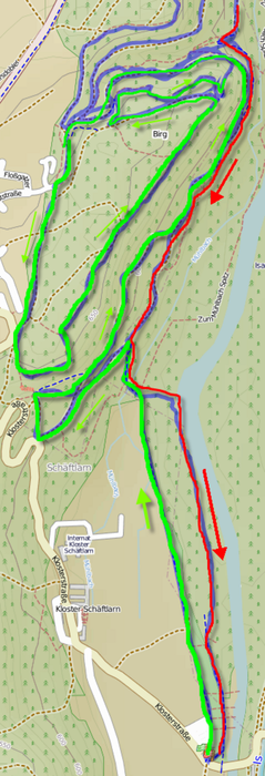
Da die Tour zum Teil Hin- und Rückweg den gleichen Streckenverlauf nutzen, sind einige Details in den 5 Grafiken dargestellt.

Grüne Markierung = Hinweg

Gelbe Markierung = Mittelteil der Tour

Rote Markierung = Rückweg


Galerija izletov

Zemljevid in višinski profil izleta

  • Open Street Map
  • Google
Minimum height 542 m Maximum height 661 m Prikaz podrobnosti

More about the tour author

WilliWitzig
Member since 2010

Send private message

Komentarji

LaUltima on 31.07.2011

...

Nicht ganz mein Geschmack, aber trotzdem ne nette Runde


Parkplatz = 47°  58'  21.1''
                   11°  28'  27.1''

Poti GPS

Trackpoints
  • GPX / Garmin Map Source (gpx) download
  • TCX / Garmin Training Center® (tcx) download
  • CRS / Garmin Training Center® (crs) download
  • Google Earth (kml) download
  • G7ToWin (g7t) download
  • TTQV (trk) download
  • Overlay (ovl) download
  • Fugawi (txt) download
  • Kompass (DAV) Track (tk) download
  • List z izleti (pdf) download
  • Original file of the author (gpx) download

More about the tour author

WilliWitzig
Member since 2010

Send private message
Share track
Add to my favorites
Remove from my favorites
Edit tags
My score
Rate
Izlet: M7-30, Schäftlarner Birg-Trail
Vrsta: Gorsko kolo
Dolžina: 21,4 km
Evaluated on:
Trajanje:
Day(s)
Hour(s)
Minute(s)
Ocena: Pokrajina Dejavnik zabave Kondicija Tehnika