Login

Si pozabil/a podatke za prijavo?

Cookies have to be accepted!
Your browser's cookie functionality is disabled. Please enable this functionality.

Not a member yet?

Register now
Login

Available for registred users only

Log in to use this feature.

Si pozabil/a podatke za prijavo?

Cookies have to be accepted!
Your browser's cookie functionality is disabled. Please enable this functionality.

Not a member yet?

Register now
Filter
Kategorije
Advanced filters
  • Dolžina (km)
  • Metri nadmorske višine
Shrani filter Reset filter

TrackRank

QRCode

Technical data

Dolžina45,9 km Metri nadmorske višine549 m Way down575 m Trajanje02:00 h:m Datum21.11.2010
Ocene Author Pokrajina Dejavnik zabave Kondicija Tehnika

Statistika

1501 Pogledi Ocene 60 Prenosi Povprečje
Rate
  • List z izleti
  • Prihod
  • Prenosi

Eine leicht wellige und einfache Trekking- oder auch Rennradtour. 99% geteerte Nebenstraßen und Wirtschaftswege.

Bei Wind kann die Strecke anstrengend werden, da viel Strecke auf freiem Feld und dann im vollen Wind gefahren wird.

ca. 35% der Strecke verläuft auf dem Kelten-Radweg (siehe Link).

Further information at

http://www.adfc-bw.de/region-stuttgart/HGK_kelten.html

Galerija izletov

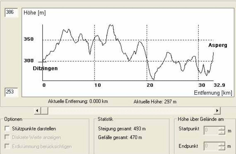
Zemljevid in višinski profil izleta

  • Open Street Map
  • Google
Minimum height 243 m Maximum height 410 m Prikaz podrobnosti

More about the tour author

ossinator
Member since 2009

Send private message

Komentarji


Z.B. mit der U6 oder S6 nach Weilimdorf


Poti GPS

Trackpoints
  • GPX / Garmin Map Source (gpx) download
  • TCX / Garmin Training Center® (tcx) download
  • CRS / Garmin Training Center® (crs) download
  • Google Earth (kml) download
  • G7ToWin (g7t) download
  • TTQV (trk) download
  • Overlay (ovl) download
  • Fugawi (txt) download
  • Kompass (DAV) Track (tk) download
  • List z izleti (pdf) download
  • Original file of the author (gpx) download

More about the tour author

ossinator
Member since 2009

Send private message
Share track
Add to my favorites
Remove from my favorites
Edit tags
My score
Rate
Izlet: Weilimdorf > Markgröningen und zurück Keltenradweg
Vrsta: Treking kolo
Dolžina: 45,9 km
Evaluated on:
Trajanje:
Day(s)
Hour(s)
Minute(s)
Ocena: Pokrajina Dejavnik zabave Kondicija Tehnika