


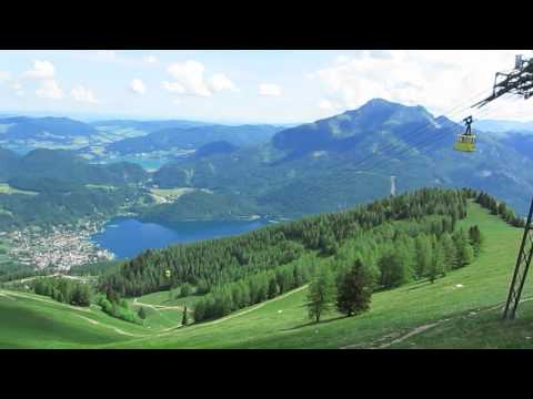
Die MTB-Tour Zwölferhorn bei St. Gilgen am Wolfgangsee startet in Brunn. Sie ist eine sehr gut beschilderte offizielle Mountainbike Tour im Bundesland Salzburg. Der kleine Ortsteil Brunn liegt zwischen Abersee und Gschwandt am Wolfgangsee Südufer. Die beste Parkmöglichkeit findest du ca. 1km weiter neben der Hauptstraße in Richtung St. Gilgen. Eine kleine Anfahrt zum Start schadet nicht, da die MTB-Tour gleich mit einer durchschnittlich 10%igen Steigung auf den ersten 1,5km beginnt (max. 15%). Die einspurige Mautstraße ist auf den ersten 1,2km asphaltiert und führt dann als Schotterstraße weiter bis zur Illingeralm hinauf. Mehr Infos findest du auf www.biketours4you.at The MTB-Tour Zwölferhorn in St. Gilgen on the Salzkammergut lake Wolfgangsee start in Brunn. She is a very well-marked official mountain bike tour in the state of Salzburg. The small village Brunn is located between Abersee and Gschwandt near the Wolfgangsee south bank. The best parking you can find about 1km off the main road to St. Gilgen. To start a little away will not hurt because the bike tour starts with an average slope of 10% on the first 1.5 km (max. 15%). The single-lane toll road is paved on the first 1.2 km and then a dirt road leads up to the pasture Illingeralm. Past Meindlalm and after Steingrabenalm there are 2 easier sections. More infos, photos and video you'll find on www.biketours4you.at
Galerija izletov

Zemljevid in višinski profil izleta
Minimum height 550 m
Maximum height 1471 m
More about the tour author
|
|
Trek1400d |
Komentarji

Die MTB-Tour startet in Brunn am Südufer des Wolfgangsee im Bundesland Salzburg. Brunn liegt zwischen Attersee und Gschwandt an der B158.
Poti GPS
Trackpoints-
GPX / Garmin Map Source (gpx) download
-
TCX / Garmin Training Center® (tcx) download
-
CRS / Garmin Training Center® (crs) download
-
Google Earth (kml) download
-
G7ToWin (g7t) download
-
TTQV (trk) download
-
Overlay (ovl) download
-
Fugawi (txt) download
-
Kompass (DAV) Track (tk) download
-
List z izleti (pdf) download
-
Original file of the author (gpx) download
More about the tour author
|
|
Trek1400d |
Add to my favorites
Remove from my favorites
Edit tags
Open track
My score
Rate