Login

Si pozabil/a podatke za prijavo?

Cookies have to be accepted!
Your browser's cookie functionality is disabled. Please enable this functionality.

Not a member yet?

Register now
Login

Available for registred users only

Log in to use this feature.

Si pozabil/a podatke za prijavo?

Cookies have to be accepted!
Your browser's cookie functionality is disabled. Please enable this functionality.

Not a member yet?

Register now
Filter
Kategorije
Advanced filters
  • Dolžina (km)
  • Metri nadmorske višine
Shrani filter Reset filter

TrackRank

QRCode

Technical data

Dolžina18,6 km Metri nadmorske višine497 m Way down506 m Trajanje00:00 h:m Datum08.07.2007
Ocene Author Pokrajina Dejavnik zabave Kondicija Tehnika

Statistika

14555 Pogledi 1 Ocena 1696 Prenosi 4.00 Povprečje
Rate
  • List z izleti
  • Prihod
  • Prenosi
Die Tour führt von Finalpia ins Gebiet LeManie.

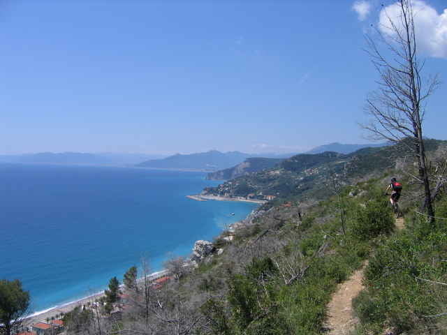
Sehr schöne Trail Passagen und teilweise traumhafter Blick aufs Meer.

Zemljevid in višinski profil izleta

  • Open Street Map
  • Google
Minimum height 2 m Maximum height 407 m Prikaz podrobnosti

More about the tour author

Simba
Member since 2007

Send private message

Komentarji

Hugo on 12.09.2008

LeManie

Tolle Tour durch die Hügel vor Finale. Im ersten Teil der Tour sind zwar einige kurz Schiebestellen drin, die aber der Schönheit der Tour keinen Abbruch tun. Für das Ende der Abfahrt nach Varigotti ist eine solide Fahrtechnik von Vorteil, sonst ist auch hier evtl. mal schieben angesagt. Mit einem All Mountain Hobel, macht die Runde auf jeden Fall mehr Spass als mit einem Hardtail. Schade nur, dass von dieser Region, welche mit Trails gespickt ist hier auf gps-tour.info kaum was zu finden war. Das Potential dieser Region (nicht nur fürs Freeriden) ist auf jeden Fall sehr groß. Ich werde sicher wieder mal vorbeischauen.
Luigi on 07.04.2009

gps Download

Ja, ist wirklich eine tolle Tour, kann man nur weiterempfehlen.
Andere Finale Trails mit GPS Download findet man übrigens auf www.mountainbike.bz

Gruß
Luis
Robbitech on 04.09.2011

Finale 2011

Bin Ende August in Finale Ligure gewesen und kann den Kommentar von Hugo (12.09.08) nur noch mal unterstreichen! Also nicht für Hardtails. Und das Hochschieben der letzten 350m fand ich nicht so gut.
Von Savona auf der A10 in Richtung Ventimiglia, Ausfahrt Finale Ligure. Von hier aus nach Finalpia.

Poti GPS

Trackpoints
  • GPX / Garmin Map Source (gpx) download
  • TCX / Garmin Training Center® (tcx) download
  • CRS / Garmin Training Center® (crs) download
  • Google Earth (kml) download
  • G7ToWin (g7t) download
  • TTQV (trk) download
  • Overlay (ovl) download
  • Fugawi (txt) download
  • Kompass (DAV) Track (tk) download
  • List z izleti (pdf) download
  • Original file of the author (gpx) download

More about the tour author

Simba
Member since 2007

Send private message
Share track
Add to my favorites
Remove from my favorites
Edit tags
My score
Rate
Izlet: Finale Ligure - LeManie
Vrsta: Gorsko kolo
Dolžina: 18,6 km
Evaluated on:
Trajanje:
Day(s)
Hour(s)
Minute(s)
Ocena: Pokrajina Dejavnik zabave Kondicija Tehnika