


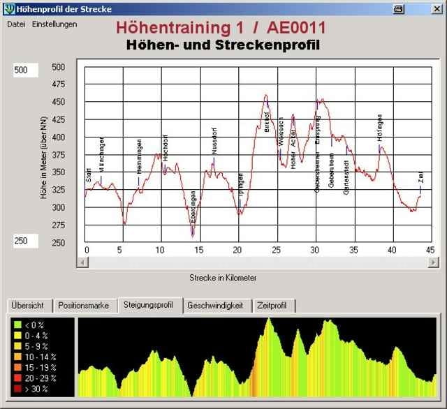
Von Ditzingen aus geht es direkt über Eberdingen nach Nussdorf ins Strohgäu. Von dort ins Heckengäu nach Iptingen, Weisach, Gebersheim. Über Höfingen führt die Straße dann wieder zurück nach Ditzingen.
Die Strecke zeichnet sich durch ein andauerndes Auf und Ab mit teilweise Steigungen um die 10 % und führt vorwiegend über Land- und Kreisstrassen; teilweise auch direkt durch Waldgebiete.
Für die Fahrzeit sollte je nach Kondition ca. 2 bis 3 Stunden (ohne Pause gerechnet) eingeplant werden.
Die Strecke zeichnet sich durch ein andauerndes Auf und Ab mit teilweise Steigungen um die 10 % und führt vorwiegend über Land- und Kreisstrassen; teilweise auch direkt durch Waldgebiete.
Für die Fahrzeit sollte je nach Kondition ca. 2 bis 3 Stunden (ohne Pause gerechnet) eingeplant werden.
Further information at
http://andreaseifert.homepage24.de/Galerija izletov
Zemljevid in višinski profil izleta
Minimum height 259 m
Maximum height 455 m
More about the tour author

|
Andreas E aus D |
Komentarji

Poti GPS
Trackpoints-
GPX / Garmin Map Source (gpx) download
-
TCX / Garmin Training Center® (tcx) download
-
CRS / Garmin Training Center® (crs) download
-
Google Earth (kml) download
-
G7ToWin (g7t) download
-
TTQV (trk) download
-
Overlay (ovl) download
-
Fugawi (txt) download
-
Kompass (DAV) Track (tk) download
-
List z izleti (pdf) download
-
Original file of the author (gpx) download
More about the tour author
|
|
Andreas E aus D |
Add to my favorites
Remove from my favorites
Edit tags
Open track
My score
Rate